With the Georgia Senate runoff results decided on December 6, 2022, the mid-term election officially comes to a close, and we can take stock of what it means for walking, bicycling, and Safe Routes to School in this upcoming Congress.
Resource Library
On Wednesday, December 14th from 11 am to noon Mountain, the Colorado Department of Transportation is hosting a free webinar presented by the Safe Routes Partnership.
Key takeaways:
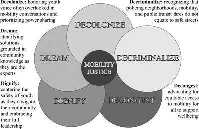
- Using the mobility justice framework means recognizing the challenges and inequities that low-income youth of color face (particularly regarding active transportation) and integrating their knowledge into the transportation decision-making process.
- This study employed community-based participatory research, specifically photovoice, which uses photography and storytelling to set priorities and advocate for change. Through a series of sessions, the five domains known as the 5 D’s of the Mobility Justice
- The 5 D’s of Mobility Justice for Youth have been adapted from the mobility justice conceptual framework model from People for Mobility Justice.

- Providing free transit was one policy solution identified to reduce inequitable access to public transportation. This policy has received pushback due to unproven, non-materialized fears that such a policy would lead to an increase in problematic passengers, that would dissuade ridership.
- Youth in this study also recommended well-lit, connected sidewalks, leading to public transportation, green spaces, and community hubs, to increase perceptions of safety and comfort with neighborhood mobility.
Last month, the Southern California Association of Governments (SCAG) concluded its 2022 Go Human Mini-Grants Program, which funded 26 safety and engagement projects a
Key takeaways:
- A community concern of “tactical urbanism” - low-cost, temporary changes to streets and roadways to increase safety, especially for people walking and biking – is that such changes increase traffic congestion and negatively impact local businesses. The findings of this case study indicate otherwise and that rather than increasing traffic, tactical urbanism contributes to “traffic evaporation” – a decrease in traffic flow following a decrease in road space.
- The study measured the relative changes in traffic following the implementation of multiple tactical urbanism interventions on eleven streets in Barcelona, Spain, during the COVID-19 pandemic.
- Four areas were studied: intervention streets (directly impacted by changes), adjacent streets (parallel to where changes took place), buffer streets (within 1/3 mile of where changes took place), and control streets (greater than 1/3 mile from where changes took place). Following the changes, traffic decreased significantly on the intervention streets, without a corresponding increase in the other three areas.
November 2022 marks the first anniversary of the Bipartisan Infrastructure Law, and we are celebrating by unveiling our new Transportation Alternatives Program tracking tool!
Every quarter, we look at how state departments of transportation (DOTs) are getting Transportation Alternatives Program money out the door so that it can build biking and walking infrastructure and support Safe Routes to School programs. Here’s the scoop on what we track and why it matters for state and local bicycle, pedestrian, and Safe Routes to School advocates updated to account for changes to the program in the Bipartisan Infrastructure Law.
On Wednesday, November 30th from 11 am to noon Mountain, the Colorado Department of Transportation is hosting a free webinar presented by the Safe Routes Partnership.
In 1969, the Nixon Administration hosted the first ever White House Conference on Hunger, and it resulted in the creation of the school lunch program and the Special Supplemental Nutrition Assistance Program for Women, Infants, and Children (WIC). In September 2022, the Biden-Harris Administration held the first White House Conference on Hunger since that initial conference over fifty years ago and established ambitious, yet attainable goals.
Communities are healthier when people can use and access parks and green spaces. This resource provides actionable strategies and inspiring examples for public health agencies to take an active role in their communities’ Safe Routes to Parks efforts.
States manage significant funding that can support Safe Routes to Parks. This factsheet lays out how states can use grant guides and project election criteria to prioritize projects backed by meaningful community engagement.
Funding reflects priorities. State funding allocations, grant programs, project selection criteria, and technical assistance programs shape communities across the state. This fact sheet covers how states prioritize goals like equity, local planning, and project implementation by incentivizing actions that move communities toward those goals. It includes examples from multiple states to serve as inspiration and ideas for how to connect these approaches to Safe Routes to Parks initiatives.
The Bipartisan Infrastructure Law made many positive changes to the Transportation Alternatives Program (TAP), including a new requirement that states define high-need communities and prioritize them in TAP project selection. Use this factsheet to see how states currently define high-need communities as part of their TAP application process and the variety of opportunities states can use to prioritize and support them.
Federal funding for local park, trail, and active transportation projects can be transformative for a community! This fact sheet profiles several
federal funding sources that have the potential to support infrastructure improvements that increase access to everyday destinations, especially parks and greenspace.
As ever, the end of the federal fiscal year has been busy with hearings, budget debates, and states running competitions for federal funding. To keep you in the loop across a variety of topics, here are a few headlines related to Safe Routes to School, walking, and bicycling at the federal level.
One of my favorite parts of Safe Routes to School is celebrating community. In my day-to-day work, I’m inspired by stories of Safe Routes programs bringing people together. Parents and engineers going on walk audits. School staff and elected officials celebrating Walk and Roll to School Day. Safe Routes to School coordinators and rotary club members installing new bike racks. Neighbors and non-profits organizing school streets pilot projects.
A couple of weekends ago, I took my son out for a special mom-and-son breakfast. As is typical of a four-year-old, he is on his millionth question of the day when he asks the waiter what his name is.
Key takeaways:
- In this study, nearly 25 percent of people consider traffic a barrier to walking. Of this group, 80 percent cite vehicle speed as the major cause of concern.
- Also of concern are the number of vehicles and distracted driving. The type of vehicle (e.g., large trucks) was not a significant concern.
- People who use walking as a mode of transportation are more likely to perceive the number of vehicles as a barrier than people who walk for recreational purposes.
- Improved sidewalks were seen as the best way to improve walkability. Other options included crosswalks, pedestrian signals, street lighting, traffic calming, separating the sidewalk/road, and road diet.
Key takeaways:
- Google Street View (GSV) was used to collect, investigate, and characterize images of neighborhood built environments. Computer vision was used to analyze the images and produce key indicators (characteristics of the built environment). The indicators were then examined for their potential influence on chronic disease and health behaviors.
- Indicators of urban development (two or more cars, streetlights, street signs) and walkability (crosswalks, sidewalks, presence of apartment and commercial buildings) were associated with lower chronic health conditions including obesity, high blood pressure, high cholesterol, diabetes, smoking, poor mental health, and depression.
- Single-lane roads were used as an indicator of lower levels of urban development and correlated with increased chronic conditions in rural areas.
- Chain-link fences were used as an indicator of physical disorder and correlated with poor mental health and depression but also decreased smoking and improved sleep.
On Tuesday, October 25th from 11 am - 12 pm MT, the Colorado Department of Transportation is hosting a free webinar presented by the Safe Routes Partnership
