This blog was written by Amy Johnson, GIS Intern, and Portland Community College student.
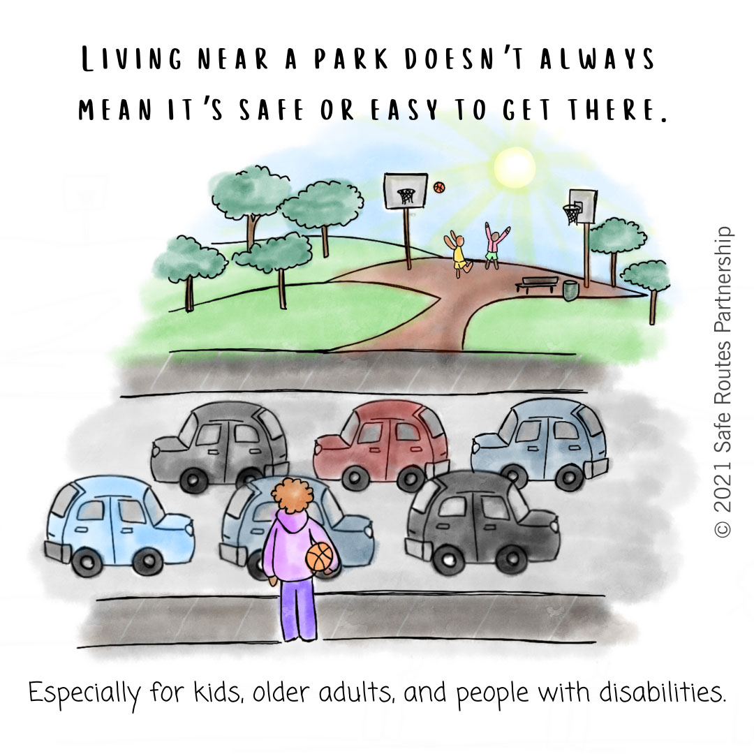
As a mom of an elementary school-aged child and a resident of Beaverton, Oregon, I love walking and riding my bike to get around. With parks and my daughter’s school close by, walking and biking should be the easiest choice for us to get where we need and want to go. Unfortunately, as in most places across the country, there are real safety concerns to deal with because our city’s roads are primarily built for people driving cars, which can put people walking and bicycling at risk. People riding bikes are forced onto busy roads due to inadequate bike infrastructure, and the experiences they share of navigating safely while traveling these precarious routes become all the more frightening when they include the precious cargo of a child. But it doesn’t have to be this way. There are effective strategies to make walking and biking safer and more appealing if we have the political will to implement them.
Even though our city has many wonderful parks, the only parks my family feels safe reaching without a car are a few blocks away or accessible via a bike path that allows us to bypass busy roads with fast cars. When I spoke to our Mayor, Lacey Beaty, in preparing to write this post, she shared that she has feared for her and her daughter’s safety when walking to a neighborhood park because of the lack of sidewalks near the park. Parks offer many benefits and cities, including Beaverton, strive to ensure all residents can access a park within a 10-minute walk from their home. But what happens when the routes we must travel to get to parks aren’t safe for pedestrians or cyclists? During my GIS (Geographic Information Systems) Internship with the Safe Routes Partnership, I sought to answer this question by applying GIS mapping tools to the concept of Safe Routes to Parks.
What can cities do to make access to parks safer? In addition to engineering solutions like more crosswalks and better sidewalks, cities can explore the idea of Park Zones. Park Zones are a concept similar to school zones, where road speeds are reduced near schools when children are present. The City of Chicago has “Children's Safety Zones”, which are reduced speed zones around schools and parks. The program literature explains that “a pedestrian hit by a car traveling 20 mph – the posted speed limit in school zones – has a 95 percent chance of surviving that crash. That same person hit by a car traveling at 40 mph has only a 20 percent chance of surviving”. By proactively lowering speed limits around areas where kids and other community members are often present, Park Zones can save lives, and all park users benefit. Park Zones can use similar signs to school zones to alert drivers to slow down and can be enhanced with engineering solutions that encourage slowing down like additional crosswalks, narrower roadways to add buffers for sidewalks, and bike paths..
We see great potential for Park Zones to become a part of a city, county, and/or state’s default road policies. Blanket policies and targeted interventions in communities with the most need can help ensure equity in Park Zones though there could be issues of disproportionate racial harm in speed enforcement without careful implementation of Park Zones. The use of engineering solutions to calm traffic in these zones rather than just changing road speeds would reduce the need for enforcement. GIS is a tool that can be used to identify road segments that parallel parks, highlight crucial intersections along park routes, and prioritize areas where Park Zones and infrastructure changes can make access to parks safer. This information can inform public outreach when solutions are being developed.
I decided to use GIS to explore the idea of Park Zones in Beaverton. Many city, county, regional, and state governments have spatial data available for download (and sometimes can be used in web mapping applications). An open-source program to work with that data is QGIS. To look at the idea of Park Zones in Beaverton, I gathered data from our regional government (Metro Regional Land Information System), the Oregon Department of Transportation, and the City of Beaverton Geographic Information Systems (GIS) Department, and used aerial imagery to support data interpretation.
One of my goals was to identify road segments that parallel park edges because those are places where pedestrians might be or park activities might overflow onto the road, say if a ball is kicked into the road or a toddler is enjoying their freedom to run without understanding the risk of entering a street. Identifying these road segments is part of the battle for understanding where Park Zones could be most necessary. Perhaps unsurprisingly, only a handful of our city's 118 named parks and natural areas lacked a street connection. One challenge I encountered was identifying the ideal distance to buffer around parks to select road segments because the road dataset is lined at the center of roads and we have wide, multi-lane arterials as well as local roads with only one lane in each direction. I can’t say that I found a magic distance that worked in all cases, but I did find a distance that didn’t include too much erroneous data or omit too much data either. In the future, I might want to determine ways to filter out cul-de-sacs and dead-end roads where there may not be an actual connection to the park.
Beyond identifying roads, I wanted to understand how busy, fast, and treacherous the streets might be, so I looked at average annual daily traffic counts, number of lanes, and speeds. I found road speeds and classification (Freeway, Principal Arterial, Arterial, etc) critical to understanding how fast traffic is passing parks, which I found in the city's functional classification dataset. To identify priority road segments, I considered the posted speed. The city has nine parks that share borders with roads with posted speed limits of 45 mph, 10 of 40 mph, three with speed limits of 20 mph, and one of 15 mph. There are very few parks that already have posted speeds in line with the 20 mph used in school zones. Many parks are paralleled by multiple roads with more than one post speed.
I also examined crash data, there were 11 parks with pedestrian or bicycle-involved crashes on road segments that parallel the park, with four fatalities. Of course, there are likely many omitted cases such as near misses or a pedestrian’s perception of danger so these data points are just a signal of what the actual conditions are. Ideally, the entire 10-minute walkshed around every park would be safe for pedestrians and cyclists though I did not attempt that analysis.
If I were to use my data to advocate for priority areas that are good candidates for Park Zones, I would suggest looking at road segments with posted speeds of 35 or above and any with pedestrian or bicyclist-involved crashes. Our city has a few linear parks bisected by streets where both sides of the road parallel the park and there is a continuous bike path. For park-goers in those parks, crossing the road is part of the experience, there are some higher speeds on some bisecting roads and my data indicate these linear parks should be evaluated as well. I can do some verification of data by looking at aerial imagery, and street views, and applying local knowledge but ultimately, walking these street segments in real-life will be necessary to verify for the GIS analysis.
I wasn’t surprised by my results, but I am left with a desire to see Park Zones become part of Beaverton or Oregon’s street policy. Beaverton's Transportation System plan is going to be updated between July 2023 and December 2025, now would be a great time to consider adopting a Park Zone policy for Beaverton.
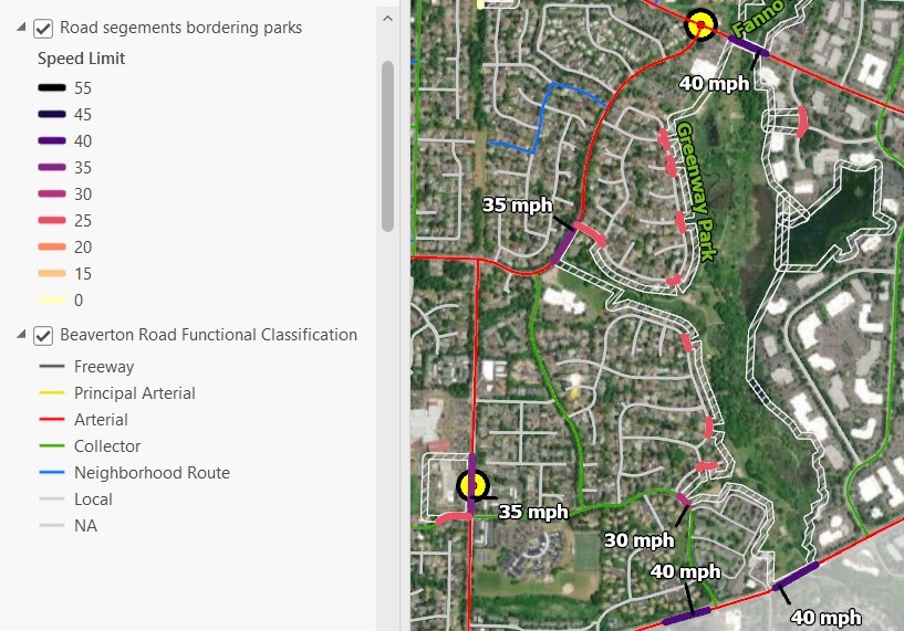
Screenshot of a small portion of Beaverton showing parks and bordering road segments with speeds 30 mph or above labeled. Two yellow circles show locations of pedestrian deaths. Road functional class is indicated by the narrow line following the road, while road segments paralleling parks are wider and color coded by speed.
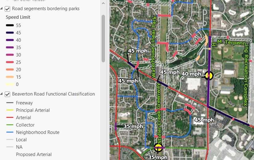
Screenshot of a small portion of Beaverton showing parks and bordering road segments with speeds 30 mph or above labeled. Two yellow circles show locations of pedestrian deaths. Road functional class is indicated by the narrow line following the road, while road segments paralleling parks are wider and color coded by speed.